Map generalization is a fundamental process in cartography, transforming complex geographic data into simplified representations suitable for various map scales and purposes. Imagine a detailed street map of a city; trying to fit all that information onto a world map would be impossible and unreadable. This is where map generalization comes in, employing sophisticated techniques to select, simplify, and aggregate features. It ensures clarity and legibility, preventing visual clutter while preserving essential spatial relationships and thematic accuracy. Understanding map generalization is crucial for anyone working with geographic information systems GIS, data visualization, or urban planning. It addresses critical questions about how we perceive space and how best to communicate spatial data effectively across different scales. This essential skill ensures that maps remain powerful tools for navigation, analysis, and storytelling, making complex geographical realities accessible to diverse audiences. Explore the techniques and challenges of this vital mapping science.
What is the primary goal of map generalization?
The primary goal of map generalization is to simplify and adapt complex geographic data for display at smaller map scales while maintaining legibility and thematic accuracy. It ensures that maps remain clear, uncluttered, and convey essential information effectively to the user, regardless of the level of detail presented. This process is crucial for creating functional and understandable cartographic products.
How does map generalization prevent visual clutter?
Map generalization prevents visual clutter by systematically reducing the density and complexity of geographic features. Techniques like feature elimination, aggregation, and simplification remove less important details or combine them into simpler representations. This targeted reduction ensures that only relevant information is displayed, making the map easier to read and interpret without overwhelming the viewer with excessive data.
What role does map scale play in generalization decisions?
Map scale is a fundamental determinant in generalization decisions, directly influencing the degree of simplification required. As the map scale gets smaller (representing a larger area), features must be generalized more aggressively to remain visible and distinct. A large-scale map might show individual buildings, while a small-scale map would generalize them into urban blocks, emphasizing the appropriate level of detail for its scale.
Can map generalization be fully automated?
Fully automating map generalization remains a significant challenge, although considerable progress has been made with GIS and AI. While rule-based systems can handle many tasks, replicating the nuanced, context-aware judgment of a human cartographer is complex. Aesthetic considerations, topological integrity, and the interpretive nature of "importance" still often require manual intervention or sophisticated machine learning models to achieve optimal results.
Why is it important to understand generalization for map users?
Understanding map generalization is crucial for map users because it helps them interpret maps accurately and critically. Knowing that maps are simplified representations allows users to appreciate the intentional reduction of detail and avoid misinterpreting generalized features. It empowers users to grasp the map's purpose and limitations, leading to more informed spatial analysis and decision-making.
H1: The Power of Map Generalization Understanding What Shapes Our Geographic World
Have you ever wondered why maps look so different depending on their scale? When you look at a globe, you see continents and oceans, but zoom into a city map, and suddenly streets and buildings appear. This incredible transformation is all thanks to map generalization, a vital process in cartography. It involves selecting, simplifying, and symbolizing geographic information to create clear and readable maps tailored for specific scales and purposes. Essentially, map generalization ensures that maps remain useful and understandable, preventing visual clutter and highlighting the most important features for the user. This ongoing refinement of spatial data, a process as old as mapmaking itself, continues to evolve with modern digital mapping and GIS technologies.
H2: What Exactly is Map Generalization Simplifying Our Complex World
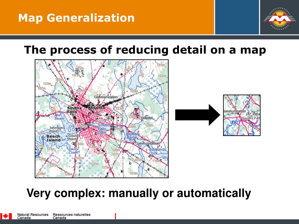
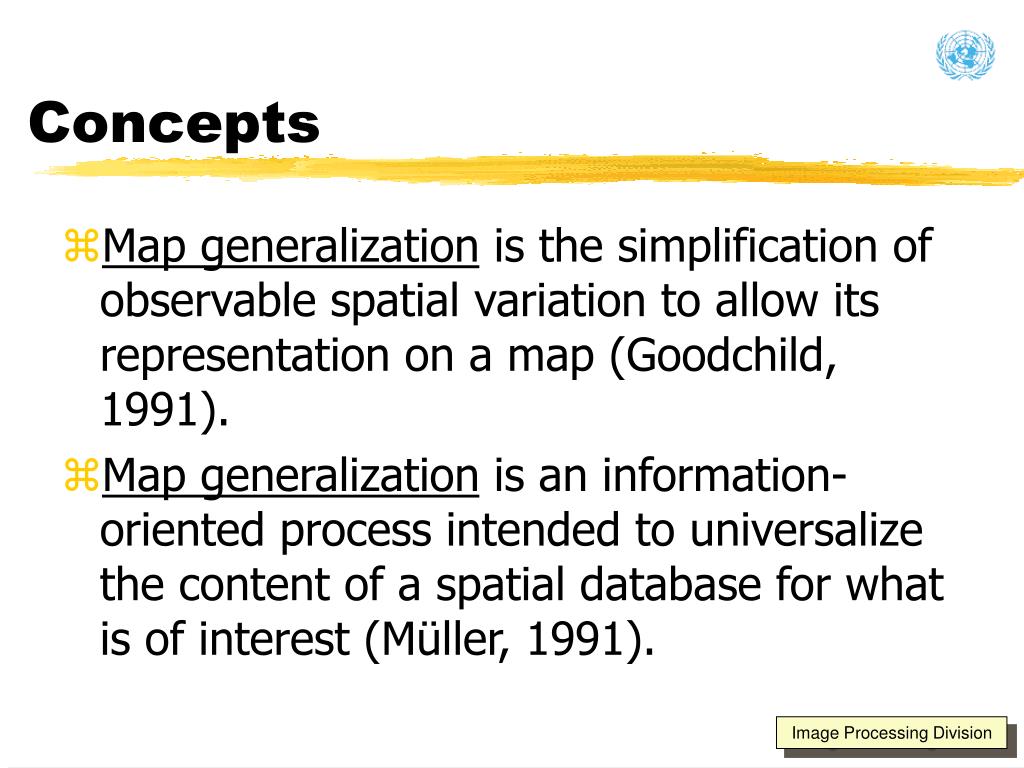
Map generalization is the fundamental process of adjusting map content to represent geographic reality at a reduced scale, while maintaining legibility and key spatial characteristics. It involves strategically removing unnecessary detail and exaggerating important features so that information remains clear and easy to understand. Imagine trying to print every single tree and fence on a map of an entire country; it would be an illegible mess. Effective map generalization avoids this, making sure that your map tells its story effectively without overwhelming the viewer. It's about smart design and intelligent data reduction, ensuring every map serves its intended audience with precision.
H2: The Core Techniques of Map Generalization Crafting Clearer Views
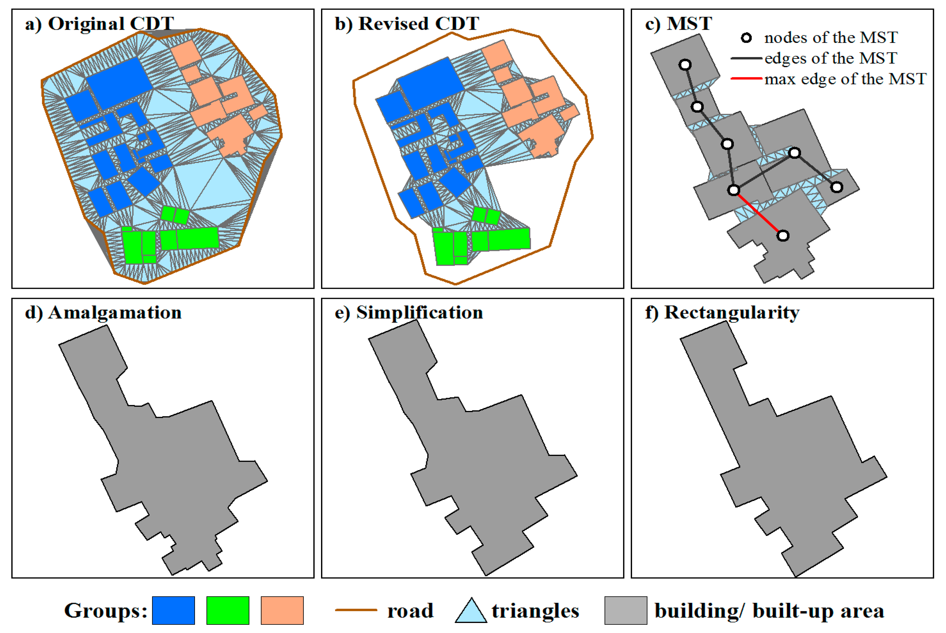
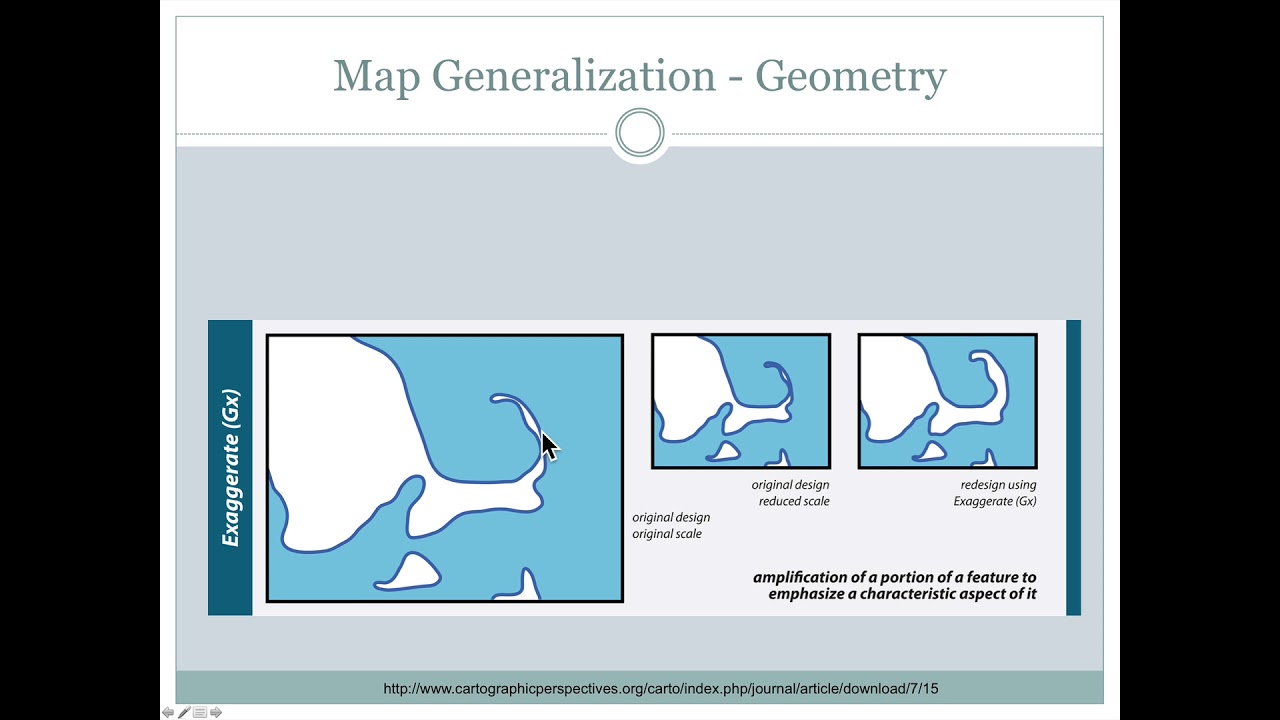
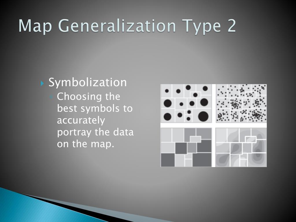
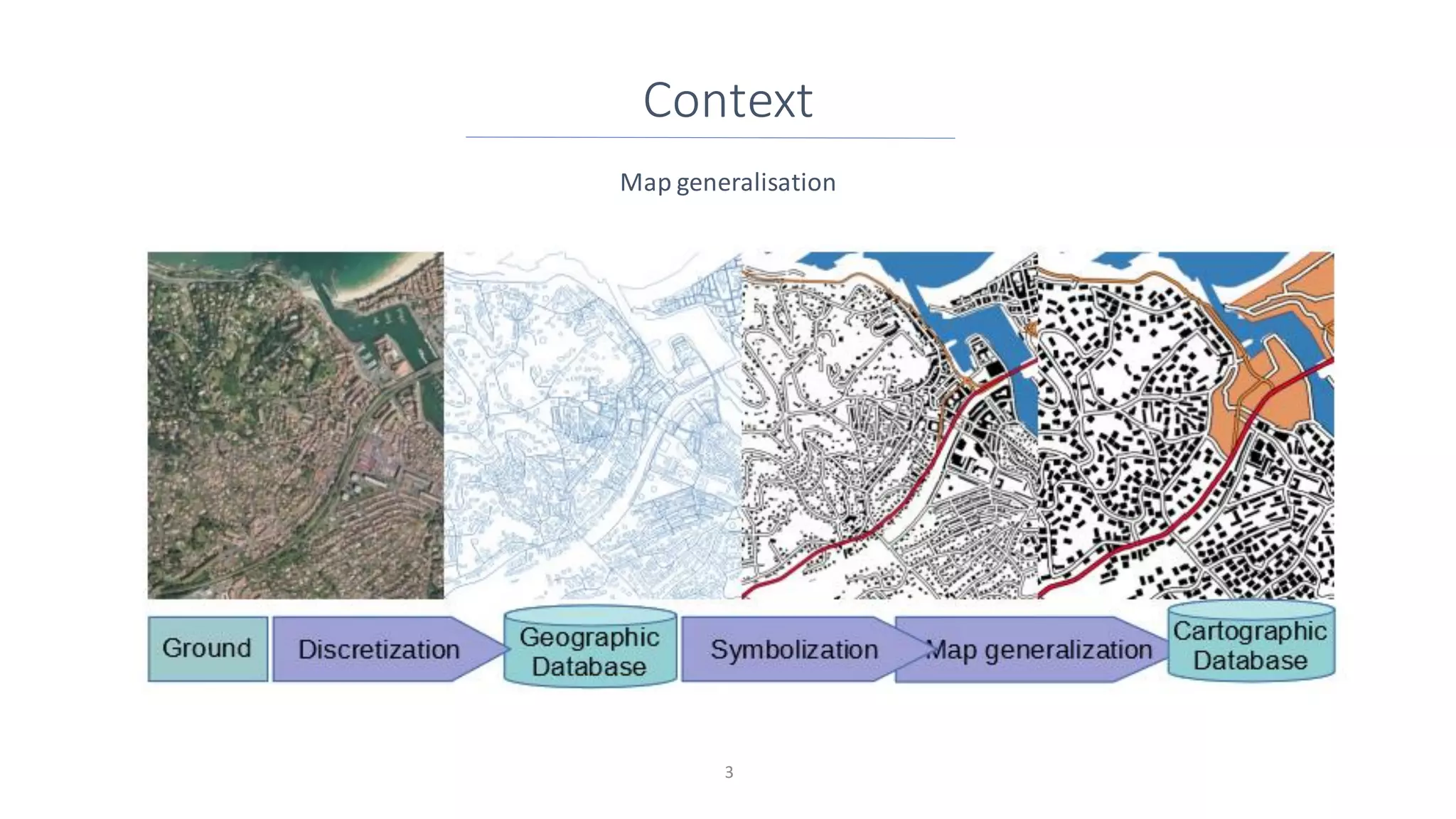
Creating effective generalized maps involves a suite of powerful techniques, each designed to simplify information while preserving its essence. You'll often see selection, where certain features are chosen for inclusion while others are omitted based on their importance at a given scale. Then there's simplification, which reduces the complexity of lines or areas, like smoothing out a jagged coastline without altering its overall shape. Aggregation combines multiple small features into a single, larger symbol, such as turning individual houses into a block of buildings. Finally, displacement subtly shifts features to prevent overlaps and ensure legibility, especially in dense areas. These methods work together to make complex geographical data digestible and visually appealing for any map user.
H2: Why Map Generalization is a Game Changer for Everyone
The impact of map generalization extends far beyond the cartographer's desk, influencing daily life in countless ways. Think about your GPS navigation system: it uses generalized road networks to show you the quickest route without cluttering the screen with every minor detail. Urban planners rely on generalized land use maps to quickly grasp large-scale development patterns. Emergency services benefit from simplified maps that highlight critical infrastructure and major routes, enabling faster response times. Essentially, generalization empowers us to make better decisions, understand complex geographies, and communicate spatial information more effectively across all sectors. It transforms raw data into actionable insights for millions.
H2: Navigating the Challenges of Automated Map Generalization
While manual map generalization is an art, automating this complex process presents significant challenges, even in 2026. Machines struggle to replicate the human cartographer's ability to interpret visual hierarchies and make subjective judgments about what is "important" on a map. Developing algorithms that can dynamically adapt generalization rules based on changing scales, map purposes, and varying geographic contexts is incredibly intricate. Overcoming these hurdles involves sophisticated AI, machine learning, and advanced spatial analysis techniques. The goal is to achieve fully automated systems that produce high-quality, human-like generalized maps, pushing the boundaries of what is possible in digital cartography.
H2: A Snapshot of Map Generalization Key Aspects
Here's a quick look at some critical elements of map generalization:
Characteristic - Description - Example
Purpose - To simplify and represent geographic data effectively at smaller scales - Making a detailed city map into a regional overview
Key Challenge - Balancing detail retention with clarity and legibility - Deciding which small rivers to keep or remove on a national map
Core Techniques - Selection, Simplification, Aggregation, Displacement, Exaggeration - Removing minor roads, smoothing coastlines, grouping buildings, shifting symbols apart
Influence - Map Scale, Map Purpose, Data Density, Feature Type - A hiking map needs more detail than a driving map
Modern Tools - GIS software, specialized generalization algorithms, AI - ArcGIS, QGIS, bespoke generalization engines
Outcome - Clearer, more readable, and functionally appropriate maps - User-friendly web maps and atlases
H2: What Others Are Asking About Map Generalization FAQ Style
What is map generalization in GIS?
Map generalization in GIS refers to the process of reducing the level of detail in geographic data as map scale decreases. It ensures that spatial information remains clear and readable on smaller-scale maps, preventing visual clutter while preserving essential geographic characteristics. This is crucial for creating effective and functional digital maps.
Why is map generalization important in cartography?
Map generalization is paramount in cartography because it enables the creation of legible and understandable maps across various scales. Without it, maps at smaller scales would be overcrowded with irrelevant details, hindering their interpretability and usefulness. It helps to communicate geographic information effectively to diverse audiences.
What are the common techniques of map generalization?
Common techniques of map generalization include selection, where features are chosen or omitted; simplification, which reduces feature complexity; aggregation, combining similar features; and displacement, subtly shifting features to avoid overlap. These methods ensure clarity and appropriate representation for the map's scale.
How does scale influence map generalization?
Map scale directly dictates the extent of map generalization needed. As the scale decreases (e.g., from 1:1,000 to 1:1,000,000), more aggressive generalization is required to maintain legibility. Features must be simplified, aggregated, or removed entirely to avoid clutter and convey the main message effectively.
What are the challenges in automatic map generalization?
Challenges in automatic map generalization stem from replicating human cartographic judgment and adapting rules dynamically. Algorithms struggle with context-aware decision-making, ensuring aesthetic quality, and maintaining topological consistency. Balancing automation with the nuanced art of cartography remains a complex hurdle.
H2: FAQ Your Essential Questions on Map Generalization Answered
What is map generalization?
Map generalization simplifies geographic data for maps at smaller scales. It's about reducing detail to ensure legibility and clarity, making complex spatial information digestible for users without overwhelming them. This process is essential for effective map communication.
Who uses map generalization?
Cartographers, GIS specialists, urban planners, environmental scientists, and anyone creating or interpreting maps for various purposes utilize map generalization. It's fundamental for presenting geographic data effectively across different scales, from local guides to global atlases.
Why is map generalization necessary?
Map generalization is necessary to prevent visual clutter and maintain legibility when displaying geographic data at smaller scales. Without it, maps would be unusable, overloaded with details irrelevant to the map's purpose. It ensures clarity and efficient communication of spatial information.
How is map generalization performed?
Map generalization is performed through techniques like selection (choosing features), simplification (reducing complexity), aggregation (combining features), and displacement (shifting features to avoid overlap). These methods are applied either manually by cartographers or increasingly through automated algorithms in GIS software.
H2: The Future of Map Generalization Smarter Maps Ahead
The journey of map generalization is far from over. With advancements in artificial intelligence and machine learning, we're seeing exciting developments in automated generalization. Imagine maps that can intelligently adapt their level of detail in real-time based on your specific needs, device, or even your current location. This future promises more intuitive, personalized, and dynamic mapping experiences for everyone. Embracing these innovations will continue to transform how we interact with and understand our world through maps. The power of spatial data is only set to grow.
Summary of Key Points about Map Generalization:
- Map generalization simplifies geographic data for clearer, legible maps at smaller scales.
- It involves core techniques such as selection, simplification, aggregation, and displacement.
- Generalization is crucial for effective communication in cartography, GIS, and navigation.
- Automating generalization presents challenges, requiring advanced AI and contextual understanding.
- The future points towards more dynamic, intelligent, and personalized generalized mapping solutions.
Map generalization is the art and science of simplifying geographic data for clearer maps at smaller scales. It involves techniques like selection, simplification, aggregation, and displacement to maintain legibility and thematic accuracy. This process is essential for effective communication of spatial information, preventing clutter and highlighting key features. Generalization balances detail retention with map purpose and scale. It is a critical component in GIS and cartographic production workflows.
35


Coordinates A Resource On Positioning Navigation And Beyond Blog F8 . PPT Design PowerPoint Free Download ID L . Interactive Map Year 2026 R . Exploring The Potential Of Deep Learning For Map PPT Exploring The Potential Of Deep Learning For Map 2 638 . Examples Of Map The First Row Shows Enhancement As The Examples Of Map The First Row Shows Enhancement As The Road In The Black


PPT FME For Data At Natural Resources Map L . Introducing The 2026 Senate Interactive Map 270toWin Senate Incumbent . PDF Automated Map Emerging Techniques And New Trends . Progressive Of Building Clusters For Map Ijgi 07 00116 G003 . Types Of Map At Ella Eales Blog Some Operations Translated And Adapted From Musti Re 2001


Taking A Look At The 2026 Senate Map YouTube . Introducing The 2026 Senate Interactive Map 270toWin Preliminary 2026 Senate Outlook . When Are The 2026 Elections . A Change Of Theme The Role Of In Thematic Mapping Ijgi 09 00371 G009 . Map YouTube


PPT Oracle Spatial And Mapviewer Problems From Real World Map L . Map Making Rules For Knowledge Amazon SL1500 . PPT Unit 1 Notes PowerPoint Free Download ID Map Type 2 L . The Essential Ingredients To Successful Map Download The Essential Ingredients To Successful Map Q640 . What Are The 2026 Elections

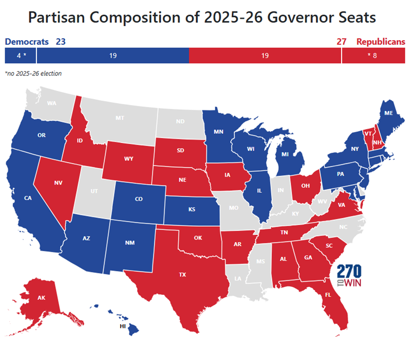


2026 Senate Sabato S Crystal Ball 2025 03 12 Senate Map . New Interactive Map 2025 2026 Elections 270toWin Governor 2025 26 Incumbent . BREAKING Proposed Texas Map Is OUT And It Will Add More Texas Proposed Congression Map 2026 768x457 . 2026 United States Elections TRUSA Wiki 1200px 2026 Senate Map . Download Scientific Diagram
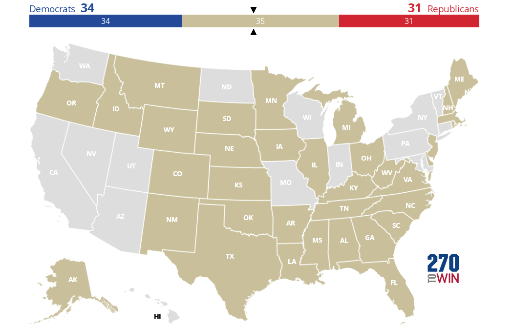
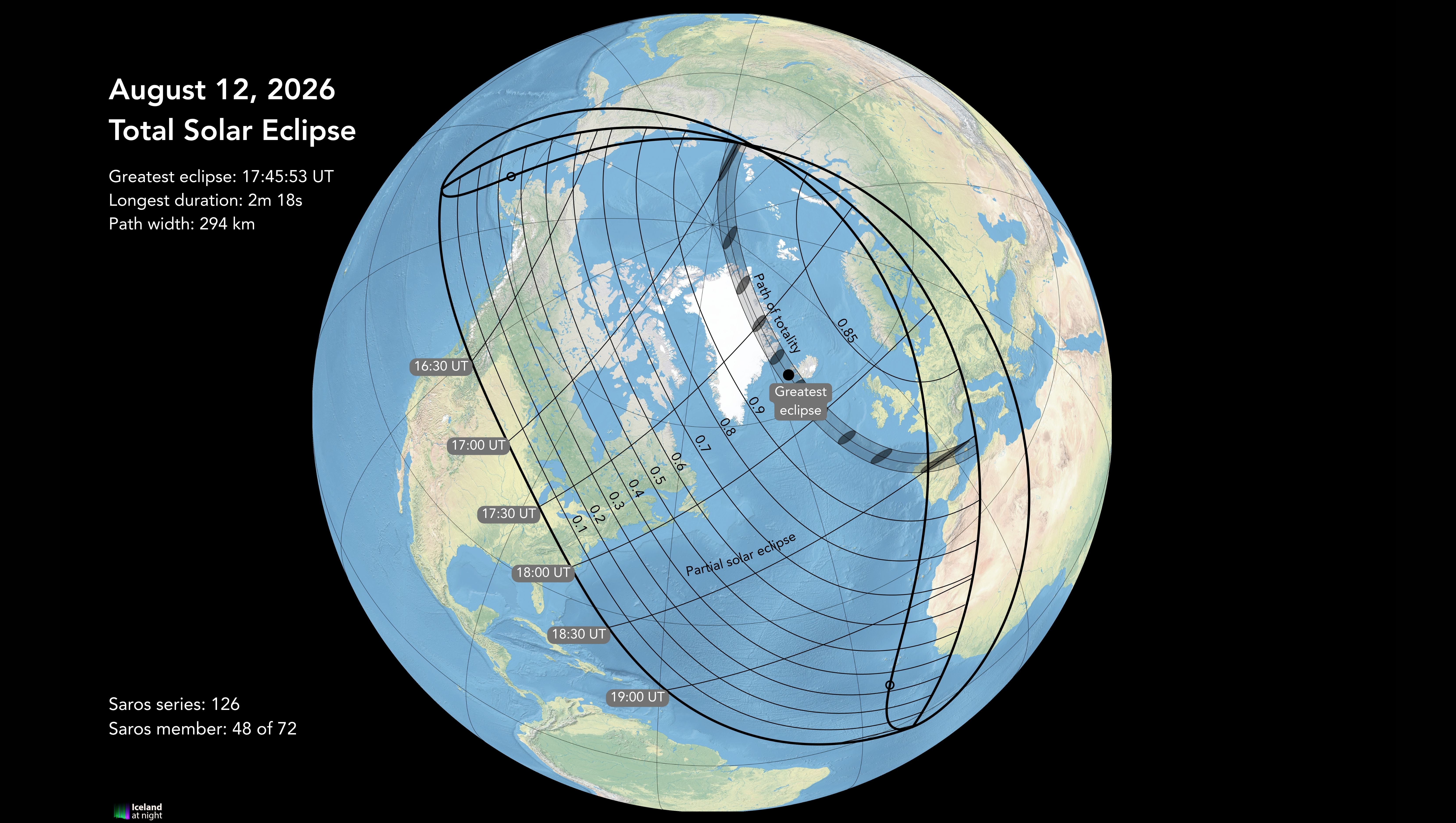


2026 Senate Elections Blank Map 270toWin MmxQpv . Maps Of Iceland For The 2026 Total Solar Eclipse Eclipse 2026 CM 9 . 2026 House Election Interactive Map 270toWin MmxBNwq . Geometric Operation Download Scientific Diagram Geometric Operation . Inside Elections 2026 House Ratings 270toWin Ie House 030725
PPT Map PowerPoint Free Download ID 151039 Map N . PPT Unit 1 Notes PowerPoint Free Download ID Map L . Iceland 2026 Solar Eclipse Guide Magnetic North Travel 2026 Total Solar Eclipse Greenland Iceland Map 2 1024x645 . PPT Map PowerPoint Free Download ID 151039 Concepts4 L . Vector Geographic Information As A Tensor For Deep Vector Geographic Information As A Tensor For Deep Learning Based Map 3 2048